


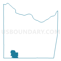
ELMONT Voting District, Franklin County, Missouri
About
Outline

Summary
| Unique Area Identifier | 607785 |
| Name | ELMONT Voting District |
| County | Franklin County |
| State | Missouri |
| Area (square miles) | 17.83 |
| Land Area (square miles) | 17.77 |
| Water Area (square miles) | 0.06 |
| % of Land Area | 99.68 |
| % of Water Area | 0.32 |
| Latitude of the Internal Point | 38.23722080 |
| Longtitude of the Internal Point | -91.23809680 |
Maps

Graphs
Select a template below for downloading or customizing gragh for ELMONT Voting District, Franklin County, Missouri


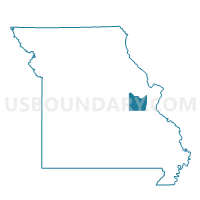
Neighbors
Neighoring Voting District (by Name) Neighboring Voting District on the Map
- Bourbon Voting District, Crawford County, MO
- JAPAN Voting District, Franklin County, MO
- SPRING BLUFF Voting District, Franklin County, MO
- Sullivan Voting District, Crawford County, MO
- SULLIVAN OUT OF TOWN Voting District, Franklin County, MO
- SULLIVAN WARD 2, Franklin County, MO
Top 10 Neighboring County Subdivision (by Population) Neighboring County Subdivision on the Map
- Meramec township, Franklin County, MO (9,382)
- Boone township, Crawford County, MO (5,892)
- Boone township, Franklin County, MO (5,401)
Top 10 Neighboring Place (by Population) Neighboring Place on the Map
Top 10 Neighboring Elementary School District (by Population) Neighboring Elementary School District on the Map
Top 10 Neighboring Unified School District (by Population) Neighboring Unified School District on the Map
Top 10 Neighboring State Legislative District Lower Chamber (by Population) Neighboring State Legislative District Lower Chamber on the Map
Top 10 Neighboring State Legislative District Upper Chamber (by Population) Neighboring State Legislative District Upper Chamber on the Map
Top 10 Neighboring 111th Congressional District (by Population) Neighboring 111th Congressional District on the Map
Top 10 Neighboring Census Tract (by Population) Neighboring Census Tract on the Map
- Census Tract 8005, Franklin County, MO (7,201)
- Census Tract 4501.02, Crawford County, MO (6,187)
- Census Tract 8011.02, Franklin County, MO (4,086)